John Konrad -
Reaching from Chile up to the Bering Sea, then down again to New Zealand, the fault lines circling the Pacific Ocean are named The Pacific Ring of Fire and are collectively responsible for many fo the world’s most devastating earthquakes.
The most infamous of these faults, at least for residents of the United States, is California’s San Andrea fault, a continental strike-slip that runs a length of roughly 810 miles along the California coast.
But little is known about the geology of faults far below the earth’s surface. In 2002, scientists in Parkfield California took the first steps to better understand earthquakes by drilling deep into the San Andreas Fault Zone to install instruments near the initiation point of previous high magnitude quakes.
This experiment was followed in 2004 when a second hole was drilled reaching a depth of 3.4 kilometers below the surface.
While this experiment proved effective, it’s location was less than ideal. First, being landbased, 100% of the drilling depth was through the earth’s surface, limiting the total depth of the experiment.
Offshore drilling operations often reach greater depth because, being in the water, up to the first 10,000 feet of depth does not require any drilling.
Second, the last magnitude 6 earthquake at the site was recorded in 1966, too long ago for optimal results.
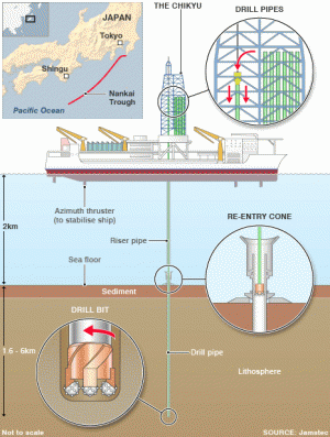
In January 2005, with drilling on the San Andreas fault near completion, scientists on the other side of the ocean took delivery of a groundbreaking ship built to address the shortcomings of Parkfield.
Costing nearly $1 billion dollars, the drillship named Chikyu, the Japanese word for “Earth”, was designed to bore through the mantle of its namesake to explore the inner workings of earthquakes at depth.

Posted via http://maritime-news.posterous.com Maritime-News posterous
.jpg)
No comments:
Post a Comment